Funded Research
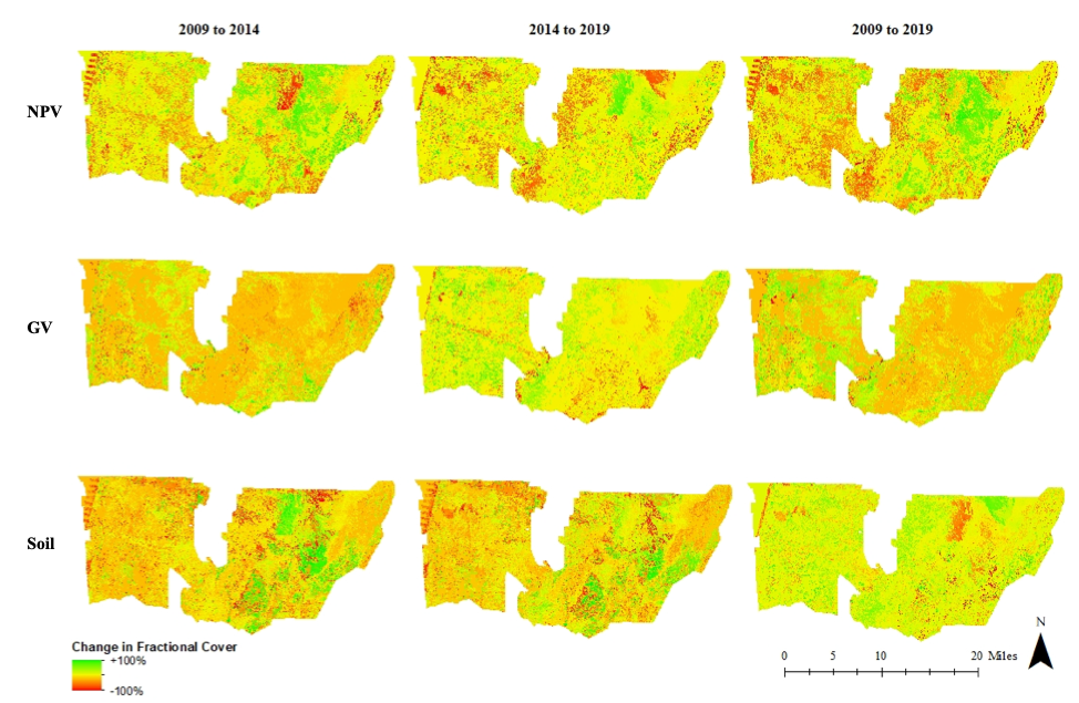
30-Year Synoptic Record of Vegetation Dynamics at Sevilleta National Wildlife Refuge
- Funder:
- Sevilleta LTER
- PIs:
- Christopher Lippitt (Department of Geography and Environmental Studies, UNM)
- Jennifer Rudgers (Department of Biology, UNM)
- Students:
- Rowan Converse
Sevilleta National Wildlife Refuge (SNWR) is home to a long-term ecological research site (LTER) located within a network of long-term monitoring sites funded by the National Science Foundation. The Sevilleta LTER seeks to understand the impacts of climatic variability on dryland dynamics. ASPIRE is partnering with the LTER to develop a thirty-year map of vegetation dynamics to illuminate these p... read more
Admin Supplement to Superfund Research Program (SRP)

- Funder:
- National Institute of Environmental Health Sciences
- PIs:
- Yan Lin (Department of Geography and Environmental Studies, UNM)
Admin Supplement to Superfund Research Program (SRP) Center, External Use Case: Arsenic Mass Balance: Integrating Environmental and Biomarker Data across Diverse Populations The objective is to build data science capacity to enable interoperability and reuse of data for projects and cores within the SRP center (internal use case), and to support collaborative activities across two or more centers... read more
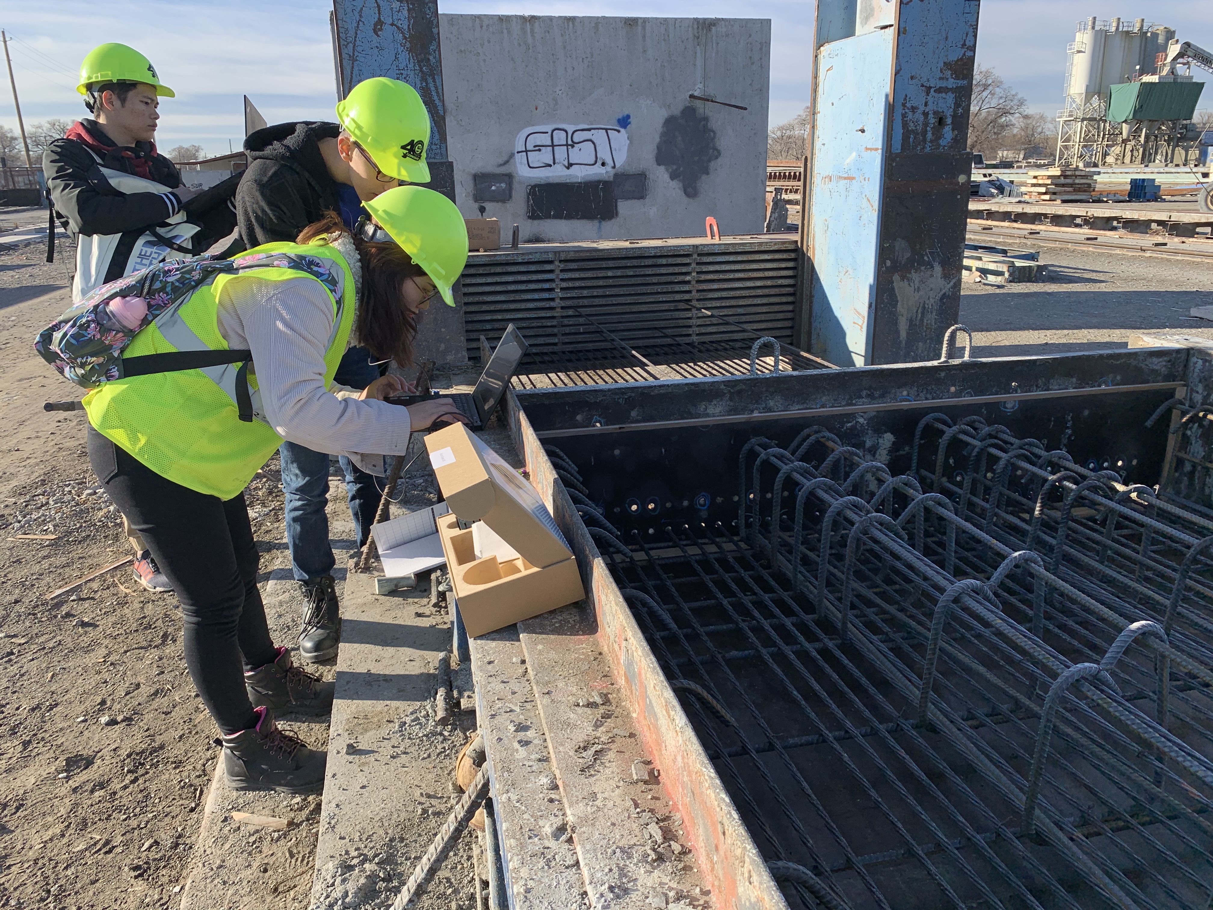
Bridge Construction Monitoring Using LiDAR for Quantified, Objective Quality Control/Quality Assurance (QOQCQA)
- Funder:
- US Dept of Transportation, University of Tennessee Chattanooga, Tran-SET
- PIs:
- Fernando Moreu (Department of Civil Engineering, UNM)
- Christopher Lippitt (Department of Geography and Environmental Studies, UNM)
- Students:
- Xinxing Yuan
This project will develop and implement a methodology to measure construction progress and compare it with the projected 3D shape, quantifying the difference as an automated method of quality control. These methods will further be used to develop Department of Transportation (DOT) standards for future bridge construction. The participation of experts in infrastructure maintenance and LiDAR sensin... read more
Drones for Ducks

- Funder:
- US Fish and Wildlife Service
- PIs:
- Christopher Lippitt
- Grant Harris
- Students:
- Rowan Converse
- Jesse Sprague
- Mohammad Mustafa Sa'doun
We are collaborating with the US Fish and Wildlife Service (USFWS) to develop a more efficient and less invasive method to count and identify species of migratory waterfowl at wildlife refuges across New Mexico. Imaging surveys were conducted using unmanned aerial vehicles (UAVs) at Bosque del Apache and Maxwell National Wildlife Refuges to census migratory birds. Birds were then manually counted... read more
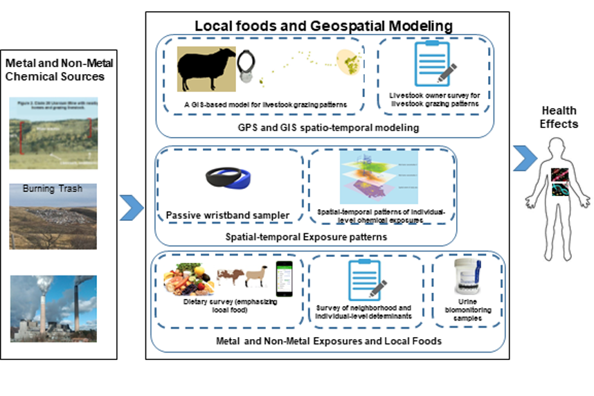
Evaluating Cumulative Environmental Exposure to Metals and Non-metals and Community-level Health Using Geospatial Modeling and Personal Exposure Assessment
- Funder:
- NIH / National Institute on Minority Health and Health Disparities
- PIs:
Tribal communities are concerned about the impact of environmental contamination on their health as well as the health of their animals. Sources of environmental contaminants on tribal lands include abandoned mine waste, power plants, oil and gas production, pesticide use, and open burning / dumping of trash. Pollutants are released to the environment through different pathways: water, air, soil,... read more
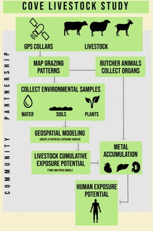
GPS Tracking Livestock Movement and Exposure to Abandoned Uranium Mine Waste in Cove Watershed
- Funder:
- Environmental Protection Agency
- PIs:
- Yan Lin (Department of Geography and Environmental Studies)
- Johnnye Lewis (College of Pharmacy, UNM)
- Students:
- Daniel Beene
- Zhouming "Leo" Liu
This project is in partnership with Cove community in the Navajo Nation, researchers at Dine’ College, the Navajo Nation Tribal College, Northern Arizona University, and Montana State University – Billings (MSUB). The research project objectives are to 1) model the potential for livestock exposure to waste from abandoned uranium mines (AUMs) using GPS; 2) measure uptake of uranium and... read more
New Mexico Riparian Habitat Map Supplement
- Funder:
- New Mexico Department of Game and Fish
- PIs:
- Esteban Muldavin (Natural Heritage New Mexico)
- Christopher Lippitt (Department of Geography and Environmental Studies, UNM)
- Su Zhang (Earth Data Analysis Center, UNM)
- Students:
- Pratistha Sharma
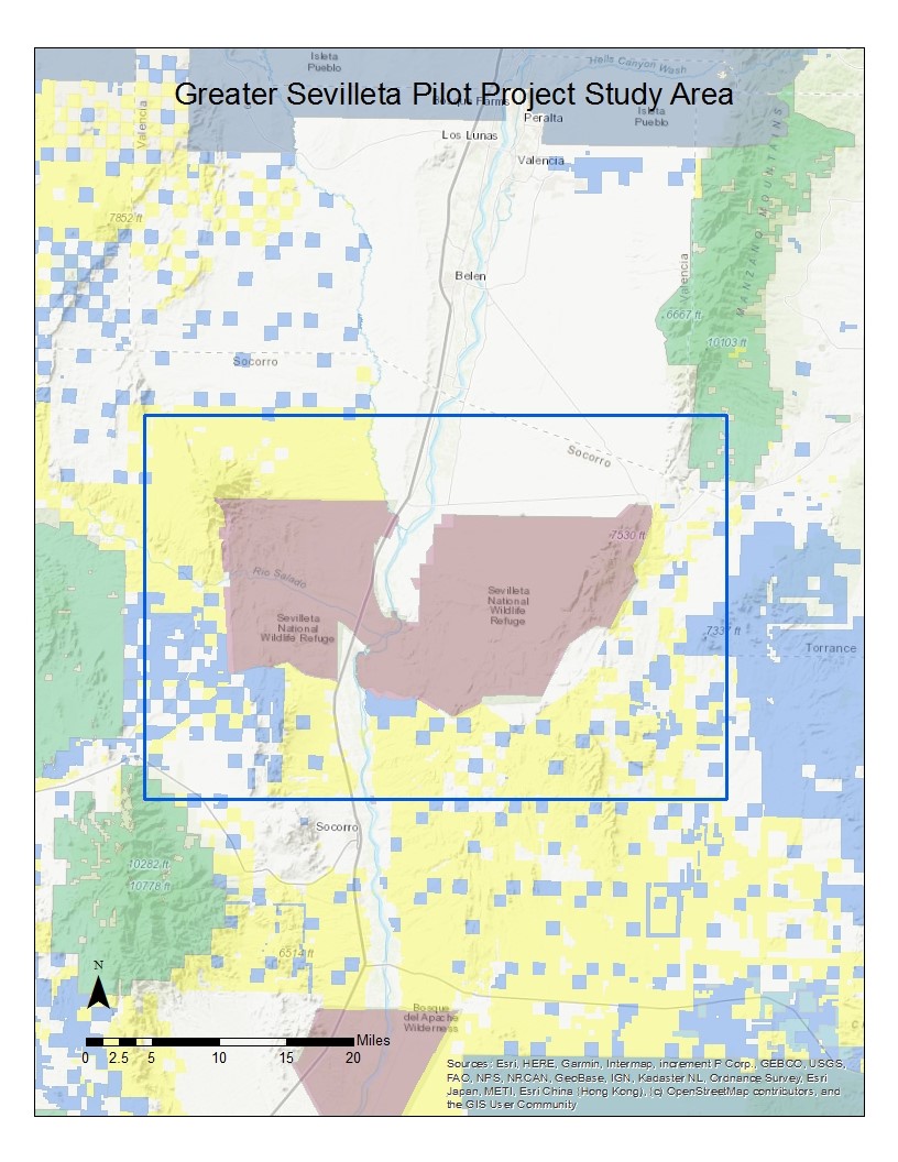
This pilot project will develop a pilot terrestrial wildlife habitat map that will provide the necessary guidance for completing a statewide map. The pilot project will focus on two representative study areas that will cover a breadth of New Mexico habitats: 1) a Greater Sevilleta Site with grasslands, desert scrub, open conifer woodlands on the Sevilleta National Wildlife Refuge and surrounding ... read more
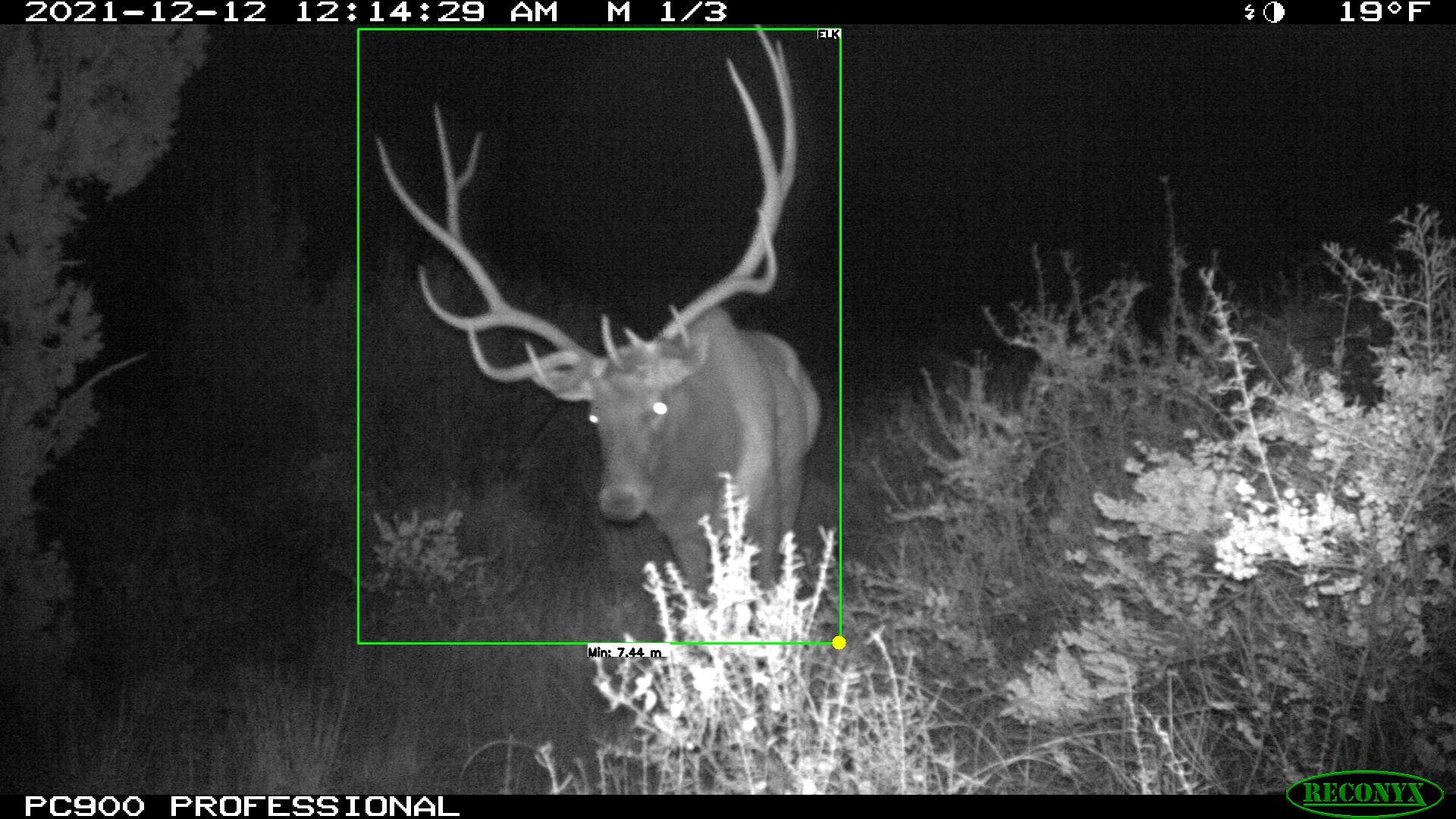
Sevilleta Camera Trap Project
- Funder:
- US Fish and Wildlife Service
- PIs:
- Grant Harris (Fish and Wildlife Service )
- Christopher Lippitt (Department of Geography and Environmental Studies )
- Students:
- Blair Mirka
- Rowan Converse
- Michael Gurule
... read more
SIPI TCUP
- Funder:
- National Science Foundation
- PIs:
- Christopher Lippitt (Geography and Environmental Studies)
- Mark Stone (Civil Engineering)
- Laura Crossey (Earth and Planetary Sciences)
- Ricardo González-Pinzón (Civil Engineering)
- Students:
- Jillian Rutherford
The Southwestern Indian Polytechnic Institute (SIPI) and the University of New Mexico are the joint awardees of a National Science Foundation Tribal Colleges and Universities Program (TCUP) grant. The objectives of this project are to: (1) improve instructional and research capacity at SIPI in the area of geosciences with a focus on watershed science; (2) increase the enrollment and graduation ra... read more
