Field Equipment
Request Equipment HEREASD Multispec 4 Standard

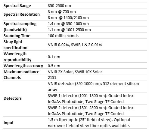
Our spectroradiometer can be used for both field and lab spectroscopy, with 2-4 nm FWHM. Includes: 1 x 350-2500nm spectrometer Field backpack Pistol Leaf clip Halon white reflectance panel Field Laptop (Lenovo) Viewspec Pro software Contact ASPIRE@unm.edu for further information or to enquire about use. ... read more
Aviatrix Flight Management System
The Aviatrix flight management system offers GPS-based flight planning and camera triggering for manned airborne imaging missions. Includes: Ublox GPS Field Laptop (Lenovo) Pilot Screen Aviatrix Flight Planning and Management Software Dual triggering Nikon D10 DSLR cameras, RGB + NIR ... read more
Balloon Photography Rig
Our balloon photography rig was designed for imaging small areas at high spatial resolutions. The setup includes a large reusable helium balloon, ground tether, and mount for a compact consumer camera.... read more
Canon SX260 (x2)
These cameras are equipped with GPS tagging to enable RGB imaging missions with our UAV fleet. Specifications: 12.1MP RGB 6.17x4.55mm CMOS 16GB Memory ... read more
DJI M210
A mid-sized UAV equipped with a MicaSense Altum sensor, a radiometric thermal camera capable of producing high resolution 5-band multispectral imagery. Used for infrastruture inspection or other larger-scale projects. Specifications: Takeoff weight <5Kg Flight Time: 30 min ... read more
DJI M600
The largest of our UAV fleet, the M600 can carry large payloads, allowing for high-resolution imaging with our DSLRs and thermal sensors. Specifications: Takeoff weight: <15.1Kg Flight time: 18 min w/ payload Payload: up to 6Kg ... read more
DJI Mavic Pro 2
The lightest of our unmanned aerial vehicle (UAV) fleet, generally used for training and demonstrations, or simple RGB imaging missions over small areas. Specifications: Takeoff weight: <1.3Kg Flight time: ~30 min ... read more
EMLID Reach RS+
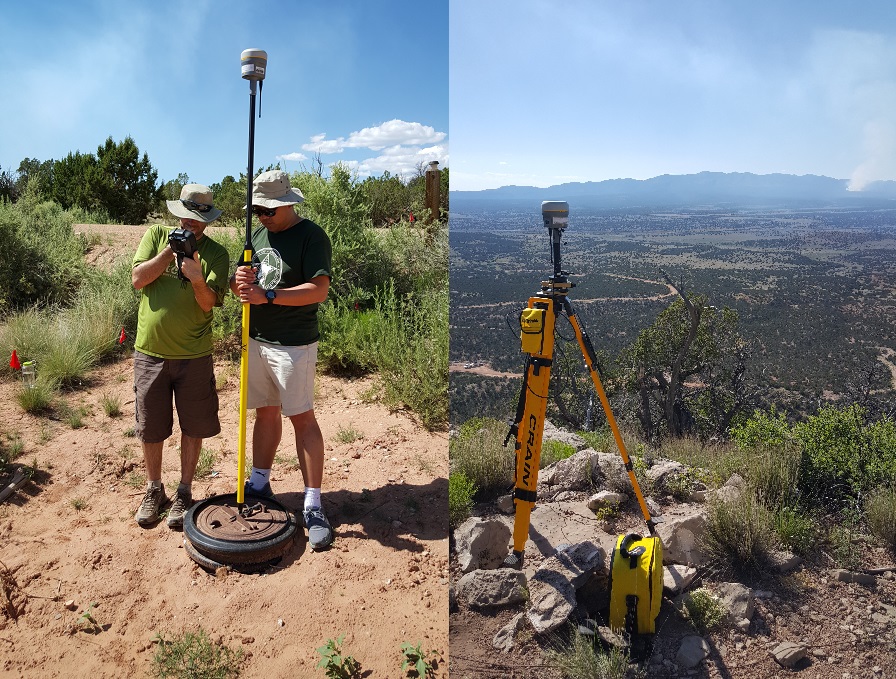
The EMLID Reach RS+ is a single-band RTK survey system with user-friendly, mobile app-based control capable of achieving centimeter-level accuracy. The system includes: 2 x RS+ receivers 2x leveled range rover poles 1 tripod support for range pole ... read more
EMLID Reach RS2
The EMLID Reach RS2 is a multi-band RTK survey system with user-friendly, mobile app-based control capable of achieving centimeter-level positional accuracy. With the M2 attachment, the system can be used for high accuracy drone mapping. The system includes: 2 x RS2 receivers 2x leveled range rover poles 1 tripod support for range pole ... read more
Nikon D810 (x2)
We currently have two Nikon D810 cameras, one configured for RGB imaging or HD Video; the other configured for NGB imaging or HD video. Specifications: 36MP RGB 24 x 36mm CMOS 128GB Memory 50mm lens ... read more
SenseFly EBEE+
The SenseFly EBEE+ is the only fixed-wing UAV in our fleet, with longer battery life and ability to image large areas. Specifications: Takeoff weight: 1.1Kg Flight time: 59 min w/ payload ... read more
Trimble R10 GNSS

The Trimble R10 GNSS is a top-of-the-line survey system with real-time kinematic (RTK) capacity, allowing for sub-millimeter accuracy. Includes: 2 x R10 receivers 2x Rover poles 2x TSC3s 1 Base tripod ... read more
Wingtra One
Our Wingtra One is a tailsitter vertical take-off and landing (VTOL) drone with a top speed of 35.8 mph and a flight time of up to 59 minutes.This UAS is importantly listed on the US Defense Innovation Unit's Blue UAS cleared list, WingtraOne GEN II (2022) is 848 FY20 NDAA compliant—tested and cleared for cybersecurity and safety.... read more
